On this page: airfield plate, pressure & density altitude calculator, flying area map, NOTAMs, METARs and wind.
Visiting aircraft are welcome at Phuket Airpark by prior arrangement – just give us a call.
Overnight parking is available for fly-in visitors with light aircraft.
Please familiarise yourself with the arrival procedure.
You must be transponder equipped to enter Phuket airspace.
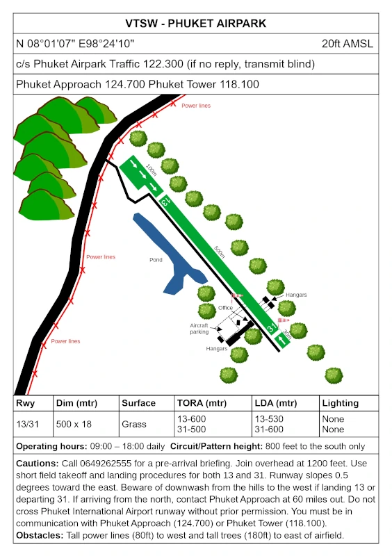
Phuket Airpark airfield plate
Click here to download an A5 PDF of the airfield plate.
Pressure Altitude & Density Altitude Calculators
Use this free tool to calculate pressure altitude and density altitude.
Use this free tool to calculate density altitude taking humidity into account.
Other useful calculators are available on this site.
Phuket Airpark flying area map
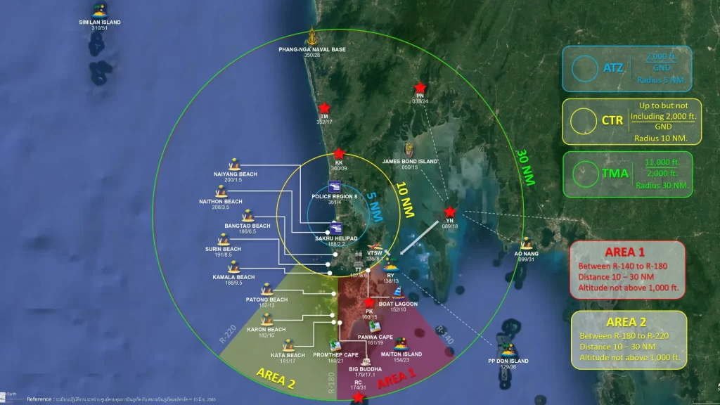
VFR reporting points around Phuket
| TM | Thai Muang district | Radial 352 – 17 nautical miles | 08°23’30.0″N 098°16’00.0″E |
| KK | Baan Khok Kloi | Radial 360 – 9 nautical miles | 08°16’00.0″N 098°19’00.0″E |
| PN | Phang Nga town | Radial 033 – 24 nautical miles | 08°26’30.0″N 098°31’30.0″E |
| YN | Ko Yao Noi | Radial 089 – 18 nautical miles | 08°07’00.0″N 098°37’00.0″E |
| RC | Ko Racha Yai | Radial 174 – 31 nautical miles | 07°36’00.0″N 098°22’00.0″E |
| PK | Phuket city | Radial 160 – 15 nautical miles | 07°53’00.0″N 098°23’30.0″E |
| TT | Thao Thep monument | Radial 157 – 8.8 nautical miles | 07°58’51.5″N 098°21’50.6″E |
| RY | Ko Rang Yai | Radial 139 – 12.7 nautical miles | 07°57’23.2″N 098°26’53.2″E |